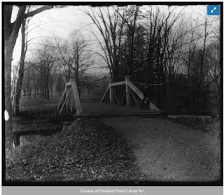
Photos of the last standing bridge illustrated in the preview to the Opening Day highlighting the Accent on Environment. The bridges spanned both sides of the Green Brook to the small island, which is accessible by foot when the water is low from Brook Ave, because the Dams have been removed but you can still see their foundations. Another bridge spanned from the Cul De Sac over the Green Brook and was going to be a feature of the neighborhood as that leads directly to the Solarium/Greenhouse and Swimming Pool which existed until about 1972 but you can see it's filled in foot-print.


Ad featuring the Bridge and Model house on Abbotsford

Survey by Olmsted Brothers Architects highlighting the dams and bridge
Farragut Road runs vertical, Brook Ave across the middle

Zoom in of the island showing the dam and bridges

a prior map of the Estate approx 1910

a 1955 survey showing the island and grassy strip donated to the Borough
so much for EJ Allen's island home to built, wonder if he got his money back?
so much for EJ Allen's island home to built, wonder if he got his money back?

Survey showing where the bridge intersected Brook Ave before the cul de sac

The island off of Brook Ave and Farragut Bridge
There is an bridge on the right and
There is an bridge on the right and
on the left or a bridge at top and a dam at bottom

unsure location but on the estate
on the Estate, but unsure where exactly

A view from Farragut Bridge

A view from Farragut Bridge

A view from Farragut Bridge

Netherwood Bridge in 1966
No comments:
Post a Comment