Saturday, March 23, 2024

Thistle Lane ... beneath the blue suburban skies....

Some of the fun in researching the Meadowbrook neighborhood history is the mystery resolving the evolution of the development but especially discovering what is missing.  And one of those missing original elements is Thistle Lane. 

This survey of Thistle Lane was formerly adopted 85 years ago on March 24th, 1939.

Curious enough it was though originally envisioned to be a part of the neighborhood, from the first public sketch in the newspaper about the sale of the "Mali Tract" April 28, 1936....

And Thistle Lane was included more formally on this sales brochure... of which is estimated to be 1940s or later, given a brief zoning note and more about that shortly.... 

Thistle Lane as drawn on the Meadowbrook brochure
carved out as a cul de sac on Mountain Ave
between Meadowbrook Road and Netherwood Road

It would seem Thistle Lane ought to have been a natural inclusion, given the neighborhood namesake Meadowbrook...

... to assume there may have been fields of thistle for the NJ state bird the Goldfinch to happily make this area a home too.

1931 view
Top left is Route 29 and Netherwood Farm
In the middle, separating two meadows is today
Meadowbrook Drive

In this November 14, 1936 article....  there are mentions of other "missing roads":  Johnston Circle, Abbey Lane, Avon Road, and Statfford Way as well as roads located across the Green Brook on the Union County side in Plainfield: Taylor Place, Beech Tree Road... 

... and about half a year later, in August 1937, an announcement of the very first sale in Union County on Boatcroft Lane, also a cul-de-sac, off of an also missing Willow Avenue... but this article also mentions the first sale on Thistle Lane as well, but with an expectation for building it the next follwing year in 1938, however...

... however, comma, in 1938 Meadowbrook Village on the Union County side was announced.... 

oh no worry, just put some already sold home photographs over that section on the sales brochure, no one will notice.... "subject to change"


But on the Somerset County side of Meadowbrook, Thistle Lane still seemed to be moving forward given the adopted survey we started off with in 1939... but it doesn't seem to stick.

There are some curious bits I don't know quite what to make of, hence more mystery.... but ultimately Thistle Lane blows away into the winds of time.

In September 1942, the Vail's sold a piece of their property to Meadowbrook Inc on the northwest side of Thistle Lane... but east of Mountain Ave feels odd?  

In January 1946 another Thistle Lane mention, about another piece of property within that area sold by Meadowbrook Inc....
In April 1946 Meadowbrook Inc requests to install fire hydrants 
... at the intersection of Meadowbrook Road and Mali Drive..... 

And... in 1947 Mr. George E. T. Wells Meadowbrook Inc President passes away... 

... so in this 1953 survey filing, the writing is on the wall, Thistle Lane is no longer about to exist.... 

and finally, March 11, 1955... it is recommended that Thistle Lane be vacated....

it's official March 12th 1955....
and one month later April 12th 1955... there are no objections... Thistle Lane is on permanent vacation.
And it won't be for another 12 years until Penny Lane is written by the Beatles, but nonetheless the lwhistful lyrics feel a fitting tribute for Thistle Lane.

Thistle Lane is in my ears and in my eyesThere beneath the blue suburban skies....


And so that concludes the story of Thistle Lane, adopted March 24, 1939, one of the many missing roads of the Meadowbrook Neighborhood.  While it didn't really exist its history nonetheless is part of the round-a-bout way the neighborhood evolved over 30 years.  


Cheers to you Thistle Lane, cheers.
 

Tuesday, March 5, 2024

Two fun maps illustrating neighborhood development in the 50s

Recently found two fun Sanborn Insurance maps recently on the Library of Congress (LOC) website of our neighborhood. Both are part of a series of maps illustrating all of North Plainfield or surrounding areas.

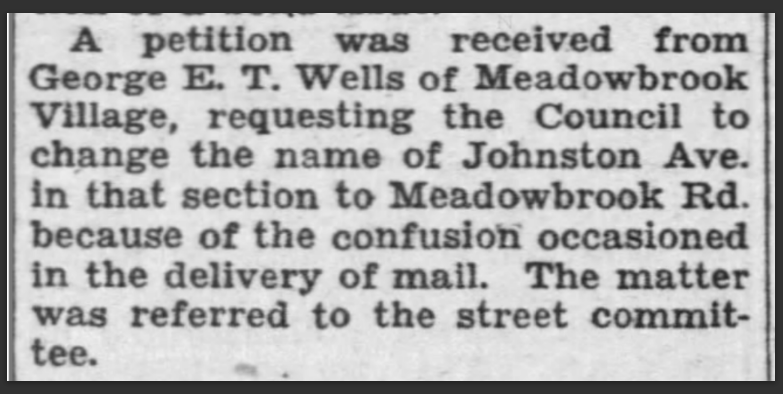
The one from 1951 shows road-label details and interestingly Wells Rd is missing but with a label still showing Johnston Ave. I think they pulled their data from an older map as that change from Johnston Ave to Meadowbrook Road was proposed back in 1939; but who knows, this is a neighborhood that took 30 years to build!

The other map is from 1956 at a lot-level detail level, showing not all houses or lots are built yet, but Wells Road is included on this map and it is connected to Netherwood Road. Recall that George E. T. Wells passed in 1947, so you'd think Wells Road would've been there in the 1951 map too, which also confirms they pulled their data from a much earlier source. I can't say what the colors mean on certain lots as I couldn't find an overall map legend but maybe you could explore the links on the LOC website, so if you figure it out, let us know!
To inspect and view these maps closer, please visit the LOC website, it is amazing how much it allows you to really zoom in deeply on them. 

Sanborn Map Company, Jan 1951 Digital Id
http://hdl.loc.gov/loc.gmd/g3814pm.g3814pm_g056011951

Sanborn Map Company, 1956  Digital Id
http://hdl.loc.gov/loc.gmd/g3814nm.g3814nm_g055751956
Enjoy!!
Update! the fun keeps on keepin' on... I just noticed other images showing the work in progress of the 1951 map, literal pasted images on top, of Meadowbrook Road turning into what was Johnston Ave... and the Johnston Ave side in Plainfield shows the missing conservatory and pool from the former Estate, which we discovered previously IRL, or suspected anyhow, but that this checks out!! The more you look at something as they say...

https://www.loc.gov/resource/g3814pm.g3814pm_g056011951/...