Recently found two fun Sanborn Insurance maps recently on the Library of Congress (LOC) website of our neighborhood. Both are part of a series of maps illustrating all of North Plainfield or surrounding areas.

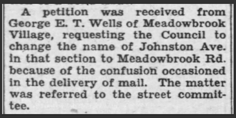
The one from 1951 shows road-label details and interestingly Wells Rd is missing but with a label still showing Johnston Ave. I think they pulled their data from an older map as that change from Johnston Ave to Meadowbrook Road was proposed back in 1939; but who knows, this is a neighborhood that took 30 years to build!

The other map is from 1956 at a lot-level detail level, showing not all houses or lots are built yet, but Wells Road is included on this map and it is connected to Netherwood Road. Recall that George E. T. Wells passed in 1947, so you'd think Wells Road would've been there in the 1951 map too, which also confirms they pulled their data from a much earlier source. I can't say what the colors mean on certain lots as I couldn't find an overall map legend but maybe you could explore the links on the LOC website, so if you figure it out, let us know!
To inspect and view these maps closer, please visit the LOC website, it is amazing how much it allows you to really zoom in deeply on them.
Sanborn Map Company, Jan 1951 Digital Id
http://hdl.loc.gov/loc.gmd/g3814pm.g3814pm_g056011951
Sanborn Map Company, 1956 Digital Id
http://hdl.loc.gov/loc.gmd/g3814nm.g3814nm_g055751956
Enjoy!!
Update! the fun keeps on keepin' on... I just noticed other images showing the work in progress of the 1951 map, literal pasted images on top, of Meadowbrook Road turning into what was Johnston Ave... and the Johnston Ave side in Plainfield shows the missing conservatory and pool from the former Estate, which we discovered previously IRL, or suspected anyhow, but that this checks out!! The more you look at something as they say...


https://www.loc.gov/resource/g3814pm.g3814pm_g056011951/...
No comments:
Post a Comment