Wednesday, December 22, 2021

Missing Mali Estate Mansion and Green Brook Pond

This image from a 1922 book titled, Plainfield and Vicinity in Pictures has perplexed me for a long time of the Frances J. Mali Mansion, address of 843 East Front Street, which was just down from the Gate House at 901 East Front Street.  Just where the heck is this large body of water, pond, and Mansion?  

Tip: Click images to enlarge them

I'm not certain how old this photograph is entirely... I have to place a solid guess that it is before a 1920's survey, more on that below, because it isn't highlighted and the Olmsted Bros Landscape Architects aren't ones to leave such an item out as you'll see in the detail screenshot.

For reference, a current day Google Map showing the distance from the Gate House 
at the corner of Johnston Avenue.
Even a republication post highlighting the Meadowbrook Neighborhood opening in 1936 makes the same reference...
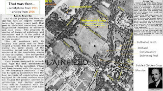
I knew of this 1936 survey that showed two dams and a bridge....
But this earlier 1928 survey, after Mrs. Mali's passing, by Olmsted Bros Landscape Architects and it only illustrates a Hay Shed, Chicken Coop, and Stable... but it does mark two dams and a bridge and clearly a large pond before the island where the word "GREEN" marks the Green Brook
Everything lines up, 1 bridge, 2 dams, and 1 pond-like pause in the flow of the Green Brook
But then, where is the house?


Netherwood Farm and the Mali Estate were host to many fire dangers over the years.
So, if the home burned or was just dismantled after the Mali's passed (Pierre 1923, Frances 1928) I'm not entirely sure...

However, today I think I found the answer to the homes location in an 1898 map survey on the Somerset County Clerk website when I searched, "Mountain Avenue" that shows the footprint of many buildings during the prime of the Estate, shortly after the passing (1893) of JT Johnston.
Look close up, you can see a bridge mid-way through the property pointing to a home directly across from the dammed Green Brook and it's slow moving pond.
Here is my attempt to color in the map, click to enlarge
So, there we have it, the slow moving pond and a mansion.

Photo solved?
 I hope you enjoyed the journey and would love to know if you have any thoughts or comments about the discovery.

Brook Scene from Farragut Road - Happy First Full Day of Winter!

Happy First Full Day of Winter!  

Winter was officially here as of 10:59 am yesterday so we are now 24 hours into it and since that was the "shortest" day of the year with 9 hours, 19 minutes, 59 seconds of daylight, things are only going to get brighter!  

Last night's Meadowbrook Neighborhood Luminary event with special guest appearances by North Plainfield Mayor La Ronde and @thegrinchmobile was memorable, looking forward to the next one and reaching out to more neighbors.

While no snow is forecast this year for awhile, here is winter 1910 Post Card to get into the mood captioned, "Brook Scene from Farragut Road" 

Also, a survey image showing where the bridge existed, right side of image, filed with the county 3 August 1936.  The dashes on the left side of the image were former dams - more on this later!

A photo of what was the final bridge, from the Open House newspaper spread later in November 1936.  

If you yourself get curious, just wonder onto the island from Brook Avenue and you can still see portions of the bridge foundation on the Union County bank of the Green Brook.  I believe the two other marks are illustrating dams and those foundational blocks still exist as well which you can see from the grassy open space patch.  

I'm going to do another longer post on Farragut Road later as the name sake is after highly decorated Civil War Admiral Farragut, himself the son of a Spanish-American immigrant and Revolutionary War veteran, and his infamous quote, "Damn the torpedoes, full speed ahead!" during the battle of Mobile.  Admiral Farragut and his son Royal were dear friend's to JT Johnston whose Quaker and Scottish upbringing united them over their shared Abolitionist views. 


Tuesday, December 21, 2021

Flyer: Hello & Welcome!

Hello & Welcome Neighbor or Fellow History Curiosity Seeker!   
If you've come to the blog based on the flyer printed, that's great!  Unfortunately the printer ran shy of ink so copies aren't too crisp or clear, and so here are better images.  Click images to view larger

More content will be posted here soon that recaps the neighborhood "anniversary", November 15, 1936 of the opening ceremonies to the public - and yet, as you'll have read in the Bio, it will take another 30 years to complete the neighborhood, which makes Meadowbrook a unique time capsule that reflects evolving tastes and preferences in lifestyles and American home architecture design.


Happy Solstice!


Thursday, December 16, 2021

Luminary Lighting Dec 21 2021

Neighborhood Luminary Lighting December 21 6pm
Special Guests arriving after 7p


Wednesday, December 15, 2021

Meadowbrook 1931

Here is a link to the pdf for a close up of the following 1931 aerial image of the Estate and notations based on the Olmsted Brothers Landscape Architecture survey for Union County.  You can clearly see the Netherwood Farm complex just North of Mountain Ave, touching what was newly opened Route 29 (predecessor to Route 22) in 1929.  

Link to image:  https://tinyurl.com/Meadowbrook1931

Link to the Olmsted survey:
https://www.flickr.com/photos/olmsted_archives/sets/72157709055298903/

Proposed neighborhood layout - 1936

Enlarged views of the full page map Published April 28, 1936 - The Proposed layout of the neighborhood published in the Plainfield Courier-News.


Mapping inequality and redlining

Mapping inequality and redlining, illustrations and descriptions, from a 1939 FHA report that highlights the Meadowbrook neighborhood and surrounding areas. Illustrating the degree to which the federal government backed mortgages and reported with direct racism is important. There will be plenty of time for fun stories and intrigue about the development of the neighborhood over the next 30 years from 1936 to 1966 and its historic residents, but very important to address the initial advertisements as a "restricted residential community" and why that specific language was used.

Source for discovering other red-lined neighborhoods in North Plainfield, visit and explore: https://dsl.richmond.edu/panorama/redlining/#loc=5/39.1/-94.58

Here is a link to a pdf incase the next few images are difficult to read on screen:
https://tinyurl.com/MeadowbrookFHAMaps

From this map we're going to view reports for areas B31, which is Meadowbrook located north of the county line , the Green Brook (solid black and dashed line) and west of Farragut Road along Brook Ave.
Next we'll look at the yellow area C43 which includes the Gate House on Front Street - note this section is graded the same as Farragut Place and what is today the East Elementary School.

And finally the red section D23...

And while these exact ratings do not exist concretely, they are nonetheless embedded in history and impact our present day boundaries of county lines, zip codes, and more recently, opportunity zones.

Plan to Develop Johns(t)on Estate of Plainfield

 Also published, 1 August 1936, the confirmation of neighborhood review by the FHA representative Emil J. J. Beechel for review in Washington.... so many typo's...

The Swimming pool still exists! ... sort of... 

Also, a note on the "park area to be established"  ... Union County had Olmsted Brothers Landscape Architects conduct a survey for a potential park.  

You can view those survey plans here, they include the swimming pool, solarium, mansion, orchard, gardens, and other features of the Estate.
https://www.flickr.com/photos/olmsted_archives/sets/72157709055298903/


A Cordial Invitation to pre-view Meadowbrook (formerly the Mali Estate)

This lengthy ad was published 1 August 1936 and illustrates the recognizable Gate House on East Front Street in Plainfield. The reason the neighborhood is listed as "a restricted residential community" is because it held the seal of the newly created FHA (1934) which profiled the potential residents.

I'll be sharing the FHA ratings in another post where you can read how the FHA rated the area based on ethnicity, religion, and occupation.


Plans for Development of Mali Tract Outlined

Published April 28, 1936. This is the first mention of the Meadowbrook "genesis" that I can find.

note: this is the Plainfield zoning board, not North Plainfield


The only other activity on the former estate published that I've found were mentions of older barns and buildings being torn down on Netherwood Farm, a brief mentioned in paragraph 3 above, in the autumn of 1935 where these were located on what is now Mountain Avenue. The farm portion of the estate extended up and over the Watchung Mountains, past Johnston Ave, and down the other side to Valley Road.


Welcome to Meadowbrook Neighborhood History - North Plainfield, NJ

Welcome to Meadowbrook Neighborhood!

Meadowbrook is a neighborhood in North Plainfield, NJ.  The first open house was 2p November 15, 1936 and is celebrating 85 years old in 2021. The neighborhood was created from the former estate and farm of John Taylor Johnston, named Netherwood.  JTJ was the first President of the Met Museum and owner of the Central RailRoad of NJ. He united the railroad from Jersey City to PA, elevated the railroad through Plainfield, creating nearby station Netherwood Station, and moved the Scotch Plains station along with the entire stretch of Rail Road to a new location named lovingly after his wife and daughter, both named Frances, who each went by the nickname, Fanny.  The Netherwood Estate and Farm was passed down to his daughter, Frances J. Mali, who married Belgain consulate Pierre Mali in 1892.

After their passing the children of Frances (December 1928) and Pierre Mali (Oct 1923) envisioned developing the holdings of the Netherwood Farms Corporation with the primary portion of the Estate and Farm encompassing the Meadowbrook Neighborhood.  The first section of Meadowbrook was approved by the Somerset County Clerk with resolution adopted by the Mayor and Council of the Borough June 26th 1936. Architect, George E. T. Wells, resided and conducted business operations from the former Mali Estate and then moved to Meadowbrook Drive in 1938.

The neighborhood is a time capsule, practically in the shape of a clock, illustrating American tastes in home architecture for three decades.  As time ticked on complex events impacted the building schedule: the Great Depression and Recession 1929-1939, World War II 1939-1945, and were further delayed by Mr. Wells unexpected death in 1947. The final section, Section 7, would not be approved by the County Clerk until August 26, 1958, built in 1966, and includes a nod to Mr. Well's legacy with the addition of Wells Road.

Please don't hesitate to contribute with your memories, recollections, photos, news clippings. 

Thank you for joining.

Insta: meadowbrookhistory_npnj

Residence group:
https://www.facebook.com/groups/meadowbrookneighborhoodhistorynpnj/ 


This map, published April 1936 in the local paper, is the envisioned plan for the neighborhood which will host its first open house November 1936... again, it will take 30 years to complete but captures changing tastes in American architecture.  Do note the extension across the county line, the Green Brook, from Somerset and Union County.... also there are various roads not built as envisioned, or not included as is the case with Wells Road.

The Old Gate-house at Meadowbrook, which is no longer a portion of the neighborhood but still exists, highlights the entrance to the former Johnston/Mali Estate across from Johnston Avenue to the Netherwood Train Station, located at 901 East Front Street Plainfield, NJ Union County

Thank you for joining us on this journey.