Saturday, March 23, 2024

Thistle Lane ... beneath the blue suburban skies....

Some of the fun in researching the Meadowbrook neighborhood history is the mystery resolving the evolution of the development but especially discovering what is missing.  And one of those missing original elements is Thistle Lane. 

This survey of Thistle Lane was formerly adopted 85 years ago on March 24th, 1939.

Curious enough it was though originally envisioned to be a part of the neighborhood, from the first public sketch in the newspaper about the sale of the "Mali Tract" April 28, 1936....

And Thistle Lane was included more formally on this sales brochure... of which is estimated to be 1940s or later, given a brief zoning note and more about that shortly.... 

Thistle Lane as drawn on the Meadowbrook brochure
carved out as a cul de sac on Mountain Ave
between Meadowbrook Road and Netherwood Road

It would seem Thistle Lane ought to have been a natural inclusion, given the neighborhood namesake Meadowbrook...

... to assume there may have been fields of thistle for the NJ state bird the Goldfinch to happily make this area a home too.

1931 view
Top left is Route 29 and Netherwood Farm
In the middle, separating two meadows is today
Meadowbrook Drive

In this November 14, 1936 article....  there are mentions of other "missing roads":  Johnston Circle, Abbey Lane, Avon Road, and Statfford Way as well as roads located across the Green Brook on the Union County side in Plainfield: Taylor Place, Beech Tree Road... 

... and about half a year later, in August 1937, an announcement of the very first sale in Union County on Boatcroft Lane, also a cul-de-sac, off of an also missing Willow Avenue... but this article also mentions the first sale on Thistle Lane as well, but with an expectation for building it the next follwing year in 1938, however...

... however, comma, in 1938 Meadowbrook Village on the Union County side was announced.... 

oh no worry, just put some already sold home photographs over that section on the sales brochure, no one will notice.... "subject to change"


But on the Somerset County side of Meadowbrook, Thistle Lane still seemed to be moving forward given the adopted survey we started off with in 1939... but it doesn't seem to stick.

There are some curious bits I don't know quite what to make of, hence more mystery.... but ultimately Thistle Lane blows away into the winds of time.

In September 1942, the Vail's sold a piece of their property to Meadowbrook Inc on the northwest side of Thistle Lane... but east of Mountain Ave feels odd?  

In January 1946 another Thistle Lane mention, about another piece of property within that area sold by Meadowbrook Inc....
In April 1946 Meadowbrook Inc requests to install fire hydrants 
... at the intersection of Meadowbrook Road and Mali Drive..... 

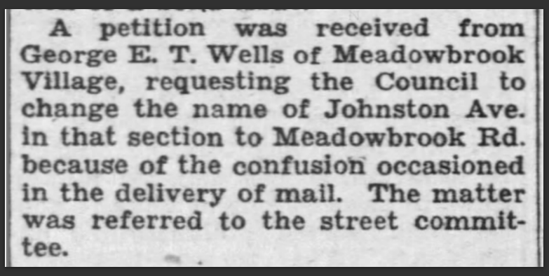
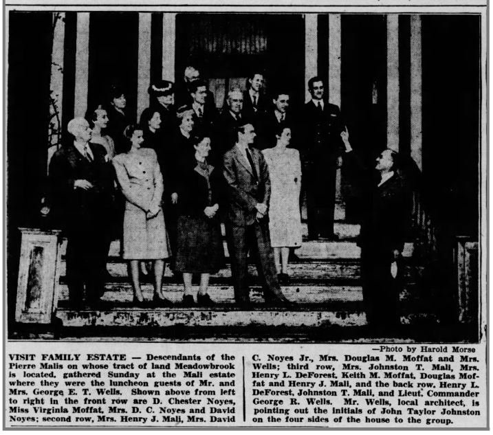
And... in 1947 Mr. George E. T. Wells Meadowbrook Inc President passes away... 

... so in this 1953 survey filing, the writing is on the wall, Thistle Lane is no longer about to exist.... 

and finally, March 11, 1955... it is recommended that Thistle Lane be vacated....

it's official March 12th 1955....
and one month later April 12th 1955... there are no objections... Thistle Lane is on permanent vacation.
And it won't be for another 12 years until Penny Lane is written by the Beatles, but nonetheless the lwhistful lyrics feel a fitting tribute for Thistle Lane.

Thistle Lane is in my ears and in my eyesThere beneath the blue suburban skies....


And so that concludes the story of Thistle Lane, adopted March 24, 1939, one of the many missing roads of the Meadowbrook Neighborhood.  While it didn't really exist its history nonetheless is part of the round-a-bout way the neighborhood evolved over 30 years.  


Cheers to you Thistle Lane, cheers.
 

Tuesday, March 5, 2024

Two fun maps illustrating neighborhood development in the 50s

Recently found two fun Sanborn Insurance maps recently on the Library of Congress (LOC) website of our neighborhood. Both are part of a series of maps illustrating all of North Plainfield or surrounding areas.

The one from 1951 shows road-label details and interestingly Wells Rd is missing but with a label still showing Johnston Ave. I think they pulled their data from an older map as that change from Johnston Ave to Meadowbrook Road was proposed back in 1939; but who knows, this is a neighborhood that took 30 years to build!

The other map is from 1956 at a lot-level detail level, showing not all houses or lots are built yet, but Wells Road is included on this map and it is connected to Netherwood Road. Recall that George E. T. Wells passed in 1947, so you'd think Wells Road would've been there in the 1951 map too, which also confirms they pulled their data from a much earlier source. I can't say what the colors mean on certain lots as I couldn't find an overall map legend but maybe you could explore the links on the LOC website, so if you figure it out, let us know!
To inspect and view these maps closer, please visit the LOC website, it is amazing how much it allows you to really zoom in deeply on them. 

Sanborn Map Company, Jan 1951 Digital Id
http://hdl.loc.gov/loc.gmd/g3814pm.g3814pm_g056011951

Sanborn Map Company, 1956  Digital Id
http://hdl.loc.gov/loc.gmd/g3814nm.g3814nm_g055751956
Enjoy!!
Update! the fun keeps on keepin' on... I just noticed other images showing the work in progress of the 1951 map, literal pasted images on top, of Meadowbrook Road turning into what was Johnston Ave... and the Johnston Ave side in Plainfield shows the missing conservatory and pool from the former Estate, which we discovered previously IRL, or suspected anyhow, but that this checks out!! The more you look at something as they say...

https://www.loc.gov/resource/g3814pm.g3814pm_g056011951/...

Wednesday, February 7, 2024

What's in a name? Origin of Meadowbrook explored

What's in a name, like Meadowbrook? Looking at this 1931 photograph, which is 5 years prior to the development starting in 1936, there's a meadow (check) and there's a brook (double check). I have a hypothesis though... Reminder, you can click the photos for larger views and for reading the captions or articles

But is there something more to it than that? Does the neighborhood owe it's namesake to the nearby "Long MeadowBrook" ? What do you think after looking at this 1862 map?

Wait, I hear you say... I've never heard of Long Meadowbrook? Sure, there's the Green Brook which borders our neighborhood and separates Union and Somerset County. But a Long Meadowbrook? Well, it's practically, long gone... In our modern day era, the Long Meadow Brook seems to remain extant within the confines of Milton Campbell field, slightly south of the former Central Railroad of NJ route which is today known as East 3rd St. Then, traveling east, the route of the old railroad on East 3rd Street, after crossing Terrill Road, turns into Midway Ave where the railroad continued to the former next station, Scotch Plains. As a reminder Mr. John Taylor Johnston moved the railroad and named that new Station after his wife and daughter both named Frances... both also known lovingly as Fanny.
Today Long Meadow Brook looks more like a drainage culvert at best but in the past before the railroad was moved to it's present day location it was at least notable on this 1862 map where it then fed into a portion of the Cedar Brook.

Note, in the 1936 article snippet it mentions the origin of place names, like "Netherwood", came from J. T. Johnston's native Scotland but that other names were sourced from our local area history, such as "Taylor Place", which does exist on this map, but never made onto the street sign names as they didn't build the section of the neighborhood in Union County.

Next is another set of images of the 1862 map with modern-day overlays from Google and Bing maps, to illustrate where our neighborhood exists on the map.

The source of this 1862 Union County topographical map was found on the Library of Congress website. Sadly, there doesn't appear to be a "sibling" Somerset County topographical map available. Here is a link to the Library of Congress website to explore the map larger yourself, highly recommended, various etchings of buildings on the margins, all in all it is a very decorative beautiful map.
https://www.loc.gov/resource/g3813u.la000467/?r=0.01,-0.435,1.111,1.603,0 https://www.loc.gov/resource/g3813u.la000467/?r=0.01%2C-0.435%2C1.111%2C1.603%2C0

Here is another article, published in advance of the neighorhood opening day with a snippet beneath explaining the naming origins by Mr. Wells.

There are some earlier 1850s maps to explore but they aren't as detailed within our area. We should be glad our neighborhood wasn't named, "Hotchkiss Machine Shop" which was located here before Mr. John Taylor Johnston started to create his Summer Estate and Netherwood Farm ... which btw, the 1862 Union County map clearly shows a widening or pond like structure in the Green Brook... yet another historic observation for the little island off of Brook Ave!

Here is a 1931 aerial photo / map, 5 years prior to neighborhood development in 1936, with road names added and the Mali (Johnston) Estate details from the 1929 Olmsted Brothers Survey completed for Union County to explore the idea of turning the former estate into a Park, similarly as they had done for Warinanco Park.
The first neighborhood advertisement published in September 1936, was quite focused on the landscape before the homes were built.
Ad with details....

Article about Meadowbrook's envisioned style from 1936


Previously I found this ad published in 1927, so concievably that is before the neighborhood was created in 1936, but I'm doubtful the Pierre and Frances Mali heirs and George Wells picked the name Meadowbrook for this reason.

Maybe in the end the name Meadowbrook was picked because it was just a meadow and just a brook, but I'm glad all the same to call Meadowbrook home.


Tuesday, February 6, 2024

Wish you were here - Vintage Meadowbrook neighborhood post cards

 Jackpot find of Meadowbrook Neighborhood history via postcards found today at some antique / vintage shops.

First, a new to me view of the Johnston Estate pond, looking west (I think?) across the Green Brook which is postmarked Nov 1st, 1906. The penmanship is atrocious, "This is ___ ___ of ____ _____ places. Really is very lovely." Can you help?
Next, an undated view of the Gate House next to Meadowbrook Village Apartments. While not post marked we can guestimate the date is after 1940s... the apartments are quite established, folks moved in 1939, but what is most interesting is the Meadowbrook Neighborhood sign from the opening day is still present from 1936... so maybe the bridge arcoss Green Brook wasn't removed until ???

And last is a winterview, also undated, showing a Birds Eye View from Watchung Mountains... in the foreground I wondered if the sparse buildings were maybe the Netherwood Farm (Mountain Ave and Watchung Square Mall today) or perhaps this view is further West, what do you think?


And one last photo of the Green Brook which separates Union County and Somerset County along Plainfield and North Plainfield. The way the bank appears in this image I think it may be the island just off of Brooke Ave.

Monday, September 25, 2023

RIP on this day 1947, George E. T. Wells, Meadowbrook architect

RIP on this day 1947, George E. T. Wells - before building our neighborhood he built Washington Park in Maplewood, NJ (across from the Yellow Rose bakery on Ridgewood Ave) in 1919, then a few hotel projects in Miami, one of which, the Watson Hotel built in 1926 on Biscayne Blvd, rebranded as the YVE Hotel, still exists today.  I'm still trying to find details on the naming of Wells Road which was done after his passing but yet to find any details.

Local newspaper Obit


NY Times Obit...

Ad for the Washington Park neighborhood in Maplewood.


Details about properties he built in Miami.... 

Photos of Theater built in Miami with pic of him too

Man-on-the-street quote after the Great Depression in NYC

As President of Meadowbrook Inc, George and also the Meadowbrook name
were actually employed by Bankers Trust Company of NYC

After his passing Bankers Trust Company wanted to make the remaining neighborhood lots not built even smaller
spurring residents to form a neighborhood association to fight it
and they won along with the Borough and County's help
to maintain the 1936 zoning as submitted.

Here is what the neighborhood looked like in 1947


The east side of Mali Drive will soon change in architecture style from the 30s and 40s
as post war trends update for the 50s and 60s
Its a chronological time capsule the evolved.


This drawing is by George E. T. Wells illustrating the proposed Meadowbrook neighborhood
on either side of the Green Brook up to Mountain Ave. to help socialize the development.
You'll notice missing components that weren't built.
The Union County Plainfield residents fought this design of and wound up with
apartments in place of houses, apartments also design by George as per
this blue print for Meadowbrook Village


You can visit George Wells, his wife Mable,
and nearby Frances and Pierre Mali 
at the Hillside Cemetery in Scotch Plains
here is a helpful map they provided
...
ironically in April 1947 the old Mali (Johnston) mansion which George had been living in
and operating from as a sales office was torn down